Wild Guide to Yorkshire
by Sarah Banks
Local Yorkshire journalist Sarah Banks shares an exerpt from her latest book, Wild Guide: North East England.
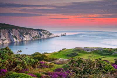
The North York Moors has one of the largest unbroken expanses of upland heather moorland in England and Wales. These rugged slopes were cut through by glacial meltwater overflowing from the north to form its dales. Looking across spectacular Newtondale from Skelton Tower, with heritage steam trains chugging along the valley bottom, you will see one of the best examples of a meltwater channel in the country.
Sarah Banks
Each of these dales has its own delights: the wild daffodils at Farndale; the abandoned ironstone railway at Rosedale, now a scenic trail for walkers and cyclists; Eskdale cut through by the lovely River Esk; and Fryup Dale, a picturesque patchwork of meadows dotted with rustic farmsteads and hamlets.
The first farmers began clearing the woodland plateau 5,000 years ago. The vast number of burial mounds and well-preserved settlement sites dating to the early Bronze Age is a distinctive feature of the moors. Some you will easily stumble across; others like the atmospheric standing stones at Simon Howe and Temple Beeld require perseverance to find. The moors are a joy to explore at any time of year, offering a sense of space and solitude, only broken by the cries of curlews, skylarks and red grouse and the buzz of bees and insects. They all find a home in the heather, which is particularly beautiful in August when a haze of purple covers the landscape. Much of the moorland of the North York Moors is open access land, meaning you can explore for miles without having to follow defined paths or tracks.
The moors are a joy to explore at any time of year…
For those seeking adventure, bouldering and scrambling opportunities abound with fantastic crags at Rosedale Head, Breckon Bank and Wheeldale. Wild swimmers can clamber down to secluded waterfalls around Goathland. The rivers here, namely the Esk and the Seven, which can be trickling streams in summer and raging torrents in winter, provide plenty of water adventures for swimmers and kayakers.
Wherever you venture here, you are never far away from a country pub, whether it is tiny Birch Hall with its own traditional sweet shop; the New Inn at Cropton, home of the Great Yorkshire Brewery; or the spectacularly situated Lion Inn at Blakey – and if you are lucky, you might even get snowed in.
WATERFALLS & RIVERS
MALLYAN SPOUT
This picturesque waterfall, the highest in the North York Moors, has charmed visitors since Victorian times. Water tumbles over a steep-sided 20m drop. Spectacular after rain but take care as rocks can be slippery. Plunge pool and more pools and swing upstream. Heading N on the A169, take L turn a at signpost for Goathland, passing Goathland. Viewpoint car park on L. Continue to Goathland village and take L at round about to park on verge. Walk back towards Mallyan Spout Hotel and follow signpost ‘Footpath Mallyan Spout’ and descend into woods. At junction at bottom, path to L leads upstream to Mallyan Spout. 20 mins, 54.3978, -0.7321 =1
SINNINGTON, RIVER SEVEN
A pebble beach at a bend in the river beneath a canopy of trees and in dappled light on summer days. Rope swing and fallen tree trunk to scramble across. From Pickering, follow the A170 for 4 miles then turn R to Sinnington. Continue on Main Street to parking at village hall (donation). Follow road to L of village hall, with river on L, to woodland footpath. Continue along riverside path, round a sharp L-hand bend in river, to a shallow ford used by horse riders. Beach is to L. Also paddle spot at 54.2669, -0.8596 with small beach and pool. 20 mins, 54.2691, -0.8691 1AT
THOMASON FOSS WATERFALL
This small, pretty waterfall with a great plunge pool in a wooded ravine on Eller Beck is reached by a narrow path. Afterwards, call in at the tiny Birch Hall Inn at Beck Hole, which has a traditional sweetshop. Heading N on the A169, take L at signpost for Beck Hole. Continue to roadside parking on hill before you descend into Beck Hole. Walk into village (½ mile). Follow signposted footpath by bridge in centre of village to falls. 25 mins, 54.4079, -0.7284 =1Wh
WATER ARK WATERFALL
Spectacular, little-known waterfall with plunge pool upstream of Thomason Foss. Further plunge pools and large flat rocks to L and R of footbridge. Tricky to reach so take care. From Goathland follow signs for Beck Hole and park at top of this road. Find footpath opp, through a snicket, and head into a field towards railway bridge (look out for steam train) and steep steps down to riverside. Cross footbridge and turn L along footpath to end, then take steep path on L down to falls. 15 mins, 54.4079, -0.7243 =AhWv
SACRED AND ANCIENT
TEMPLE BEELD STANDING STONES
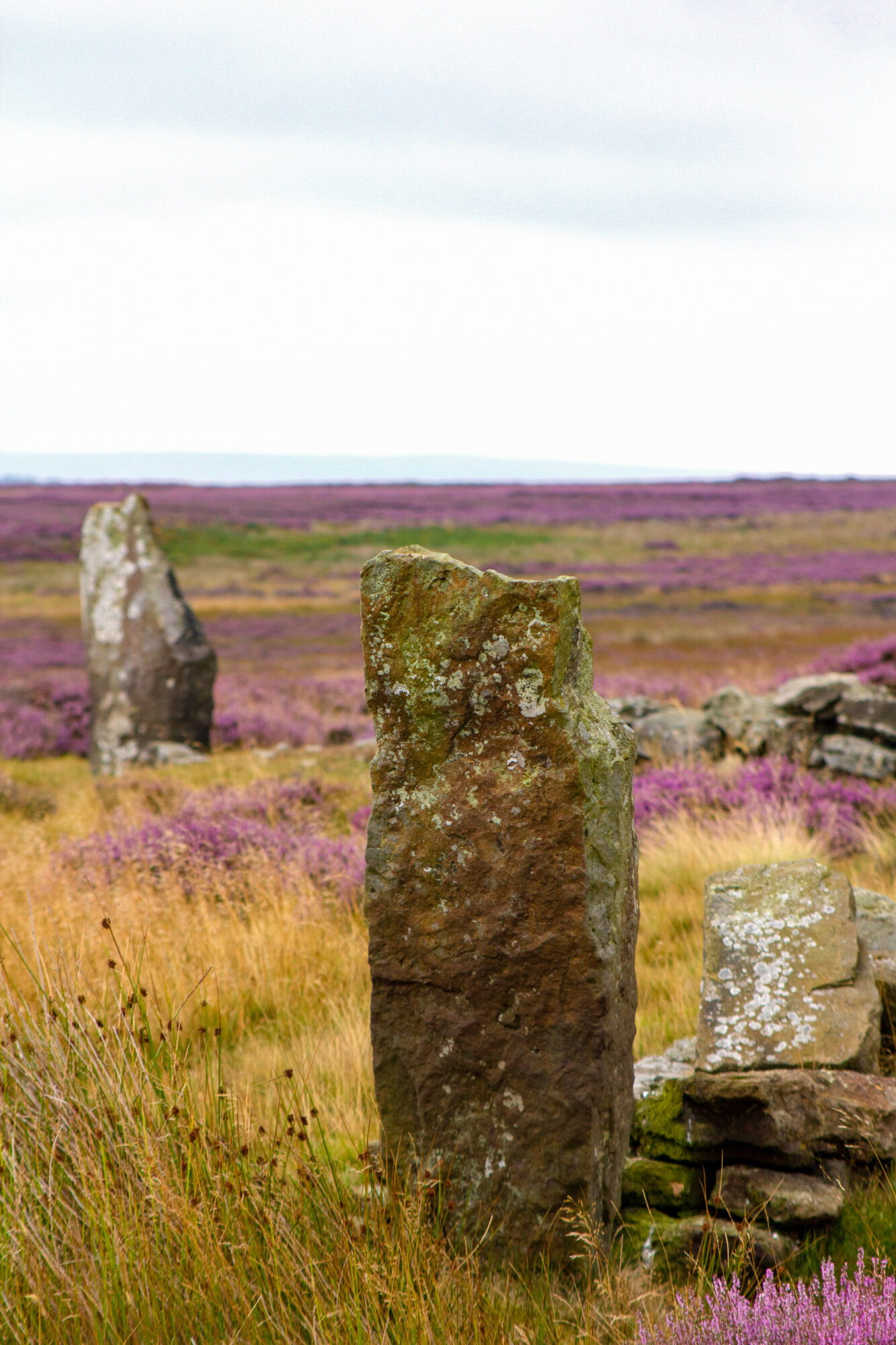
Temple Beeld Standing Stones. Credit: Sarah Banks
A set of five stones in a cross. Some have a wall built between them to provide a – ‘beeld’ a shelter for sheep. The site takes some finding as they are set in a hollow on the moorland, but it is worth the effort. The stones are thought to have been erected around 1500 bc. There are bogs on three sides, so may be best to visit in summer. From Lealholm, head uphill along the Esk Valley Walk (a road). Take the L turn to remain on the walk and park on the verge a little further up where the road takes a sharp L turn. Ahead is a track, follow this for approx ¼ mile to a T-junction with another track. Take a L here and after ¼ mile there is a track on the R with a row of grouse-shooting butts on the L-hand side. Follow this track to Temple Beeld. The stones are clearly visible on Google Earth if you need assistance finding them. There are a few barrows in the area and if you climb any, they will help you spot the stones.
30 mins, 54.4809, -0.8327 zAhv68Q
ABRAHAM’S HUT ROUND CAIRN
Buried and earthwork remains of a Bronze Age stone burial mound situated on top of a hillside overlooking the River Seven. This well-preserved, mainly stone-built cairn
was probably used for more than one burial. Such cairns are a feature of the uplands of the North York Moors and are the stone equivalent of the earthen burial mounds of the lowlands. From Hutton-le-Hole, take R turn along Moor Ln, signposted ‘Lastingham’. After ¼ mile, take a slight L to Chimney Bank and continue for 3 miles. Parking at Chimney Bank car park. Cross road to footpath sign a few metres up the hill. Pass Ana Cross on R and continue to cairn on L.
25 mins, 54.3272, -0.8643 Q68
CAWTHORN CAMP
One of the north’s lesser-known Roman sites, Cawthorn Camp is unique for the variety of its features and its survival almost 20centuries after the Romans left Britain. The two forts and camp are unusual in shape, as they form an elongated hexagon rather than the regular square or rectangle shape. A Bronze Age barrow lies in the woodland to the south-east. From Pickering on the A170, take Middleton Road, then follow Swainsea Lane. After 3½miles turn L at T-junction. In ½ mile turn R onto track to parking. Follow markers to camps. Follow woodland path behind wooden barrier to barrow.
10 mins, 54.3001, -0.8024 6Qq
CHURCH OF ST PETER AND ST PAUL
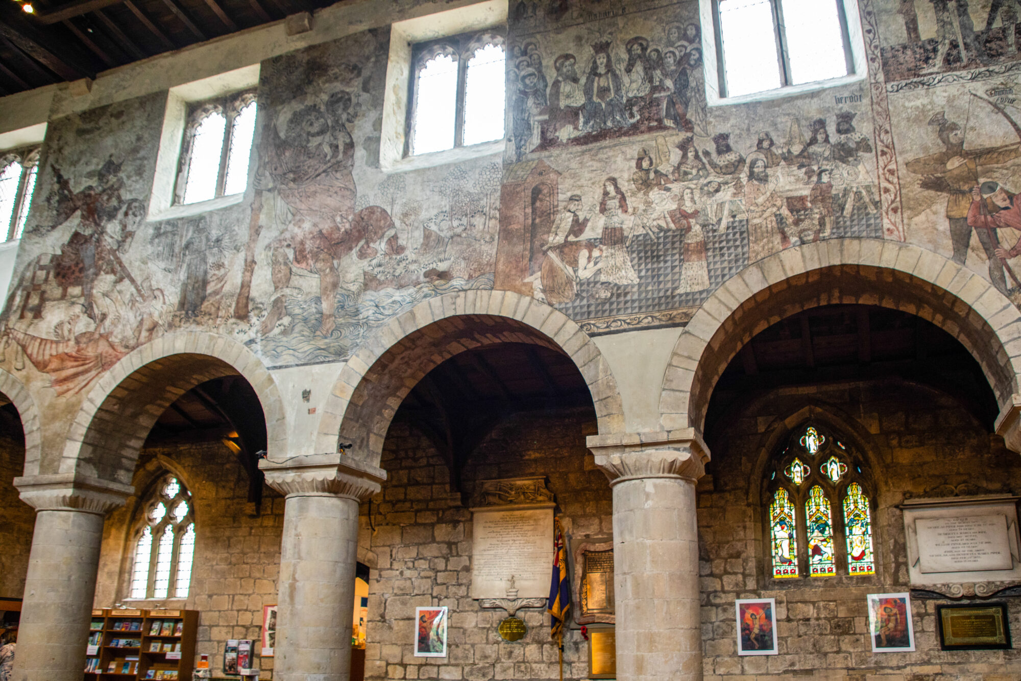
Church of St Peter and St Paul. Credit: Sarah Banks
The stunning medieval wall paintings in Pickering’s parish church are the most important of their type in Northern Europe. Originally painted in 1450, they were covered over in the Reformation, rediscovered in 1851 and almost immediately re-covered. In 1870 they were fully restored. The church is easily located from Pickering, sitting on top of a small hill in the marketplace (YO18 7AW)
5 mins, 54.2456, -0.7755 8
RUINS, CASTLES AND CAVES
PICKERING CASTLE
Church of St Peter and St Paul. Credit: Sarah Banks
A superb 13th-century castle, originally of wooden construction, founded under William the Conqueror and rebuilt in stone under Henry II. A perimeter path circles the castle. Behind is former quarry, Newbridge Park, and a short walk to Beacon Hill, a prominent summit 550m to the west and site of a former siege castle with views back to the castle and the town. Roadside parking by castle. For Beacon Hill, take footpath through Newbridge Park. Cross road at end, over beck and railway line. Then take
L along footpath to gate and across field. Continue through gate to follow footpath towards Beacon Hill (54.2495, -0.7845, private, fenced). Return same way or through town.
40 mins, 54.2502, -0.7757 e£7q
KIRKDALE CAVE
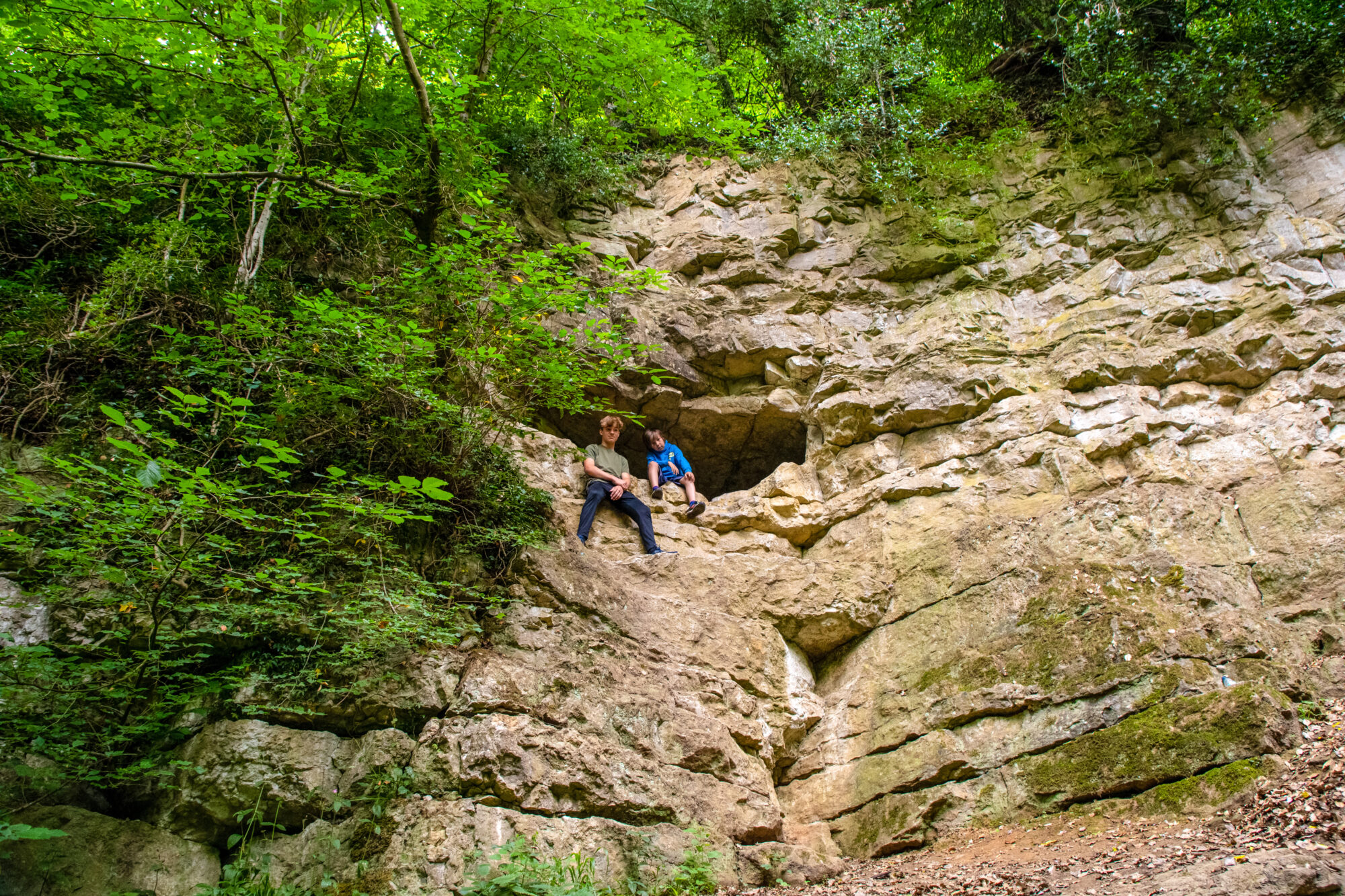
Kirkdale Cave. Credit: Sarah Banks
A slit in the rock face leads to this small cave discovered by quarry workers in 1821, along with the bones and teeth of elephants, hyenas, hippos, rhinos and bison dating back to the Ice Age. The bones, identified by William Buckland, Oxford University’s first professor of Geology, were important evidence in establishing the idea of a deep
geological past. The cave offers a short round trip near the entrance. In Kirkdale, continue past St Gregory’s Minster on L (see entry). Cross ford to lay-by parking immediately on L. Follow footpath for few metres, then turn R into a large bowl to cave in rock face. It’s a scramble to get up into the cave, possible with care and basic safety equipment. Once inside, the cave divides, with both routes extending roughly 10m
2 mins, 54.2627, -0.9617 98Ew
SKELTON TOWER
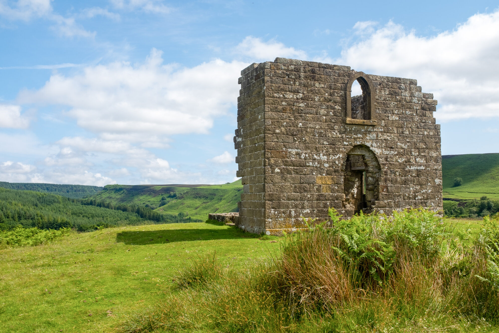
Skelton Tower. Credit: Sarah Banks
Romantic ruins of an early 19th century shooting lodge built by the local rector who used to write his sermons here and, some say, enjoy a quiet tipple. Magnificent views across Newtondale. If you are lucky, you will have timed your visit to coincide with the NYM heritage steam train passing
by. From the Horseshoe Inn in Levisham, continue down the hill for 1½ miles to the carpark at Levisham station. From the car park, continue R up the hill to a sharp bend in the road. Take the footpath L across the moor to the tower.
25 mins, 54.3258, -0.7399 67qWzh
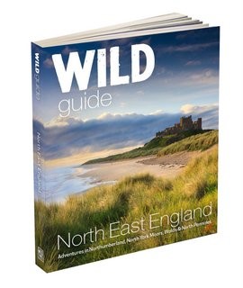
Wild Guide: North East England by Sarah Banks. Published by Wild Things Publishing. Available from 1st May 2023.
NorthernLife Mar/Apr 23